Showing 29 items matching physical geography
-
 Kilmore Historical Society
PHYSICAL GEOGRAPHY OF AUSTRALIA, Manual of Physical Geography of Australia, 1873
... PHYSICAL GEOGRAPHY OF AUSTRALIA...Manual of Physical Geography of Australia ...Green leather cover with gold writing on spine 'Physical... daylesford-and-the-macedon-ranges PHYSICAL GEOGRAPHY OF AUSTRALIA ...Green leather cover with gold writing on spine 'Physical Geography of Australia' 167 pages ; 17 cm ; Illu ; indexHandwritten inscription on first page '137' Stamp on multiple pages 'Kilmore Mechanics Institute'geography, kilmore mechanics institute library. -
 Flagstaff Hill Maritime Museum and Village
Book, Victoria Geology and Physical Geography
... Victoria Geology and Physical Geography...Victoria Geology and Physical Geography...Victoria Geology and Physical Geography Author: Reginald... Geography Victoria Geology and Physical Geography Author: Reginald ...Victoria Geology and Physical Geography Author: Reginald Murray Publisher: Government Printer Date: 1887Label on spine with typed text RA 551.09945 MUR Inside front cover has a sticker from Warrnambool Mechanics Institute and Free Library warrnambool, shipwrecked-coast, flagstaff-hill, flagstaff-hill-maritime-museum, maritime-museum, shipwreck-coast, flagstaff-hill-maritime-village, shipwrecked-artefact, book, warrnambool mechanics’ institute, reginald murray, victoria geology and physical geography -
 Greensborough Historical Society
Book, W. & A.K. Johnston, School atlas of physical geography: the elementary facts of geology; hydrography; meteorology and natural history by Alex Keith Johnston, 1871_
... School atlas of physical geography: the elementary facts of...physical geography...This atlas of physical geography has 20 plates illustrating... geography. atlas physical geography W. & A.K. Johnston ...This atlas of physical geography has 20 plates illustrating maps and various rock formations.This volume illustrates a 19th century view of physical geography.51 pages, 20 plates, maps. Red hard cover with title in gold lettering.Inscribed on fly leaf with original owner's name (1890)atlas, physical geography -
 Ballarat Clarendon College
Book, School atlas of physical geography
... School atlas of physical geography... Atlas of Physical Geography. Book in English language. Book has... goldfields Book School atlas of physical geography The book ...Robert Mitchell attended Ballarat College 1879The book was printed in 1878 year, The place of publication of the book is W & A K Johnston, Edinburgh and London, 1878. A School Atlas of Physical Geography. Book in English language. Book has cover wear and fading, modest foxing to plates. Some plates are missingHandwritten on flyleaf: R. A Mitchell July 1878 / Ballarat / RAM -
 Federation University Historical Collection
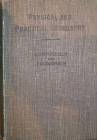
Book, Physical and Practical Geography For Secondary Schools, c1935
... Physical and Practical Geography For Secondary Schools... Book Physical and Practical Geography For Secondary Schools ...Green cloth hardcovered book of 384 pages. Includes photographic and line illustrations.signed inside cover "K.H. Wilkie 1935"geography, k.h. wilkie, marie bentivoglio, f.f. fiederich, solar system, atmosphere, barometer, wind, rainfall, temperature, climate, climatic zones, rivers, glaciers, plains and plateau, mountains, volcanoes, deserts, oodnadatta, campel transport, lakes, lake frome, shorelines, oceans, tides, latitude and longtitude -
 Robin Boyd Foundation
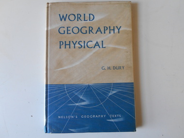
Book, G.H. Dury, World Geography - Physical, 1966
... World Geography - Physical... melbourne Book World Geography - Physical Hardcover Walsh St library ...Hardcoverwalsh st library -
 Wonthaggi & District Historical Society
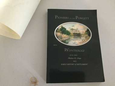
Book and Map, Barbara Moyle, Pioneers on tthe Powlett and at Wonthaggi 1878-1910, 2015
... - block numbers town names physical / geographical features... histories, maps, photograps Map - block numbers town names physical ...Book - families social histories, maps, photograps Map - block numbers town names physical / geographical featuresFarming and social history of pioneers of the Powlett River are prior to the establishment of the State Coal Mine at Wonthaggi. Significant land marks, buildings and photographs are included. Dark green cover with oval artists impression of Powlett river and bridge Associated map which covers the parishes plus key places of interestlPioneers on the Powlett and at Wonthaggi 1878-1910 Barbara R Moyle 2015 Early History of Settlement Map - Parish names, significant sitesfarming, pioneers of wonthaggi and district, wonthaggi families -
 Federation University Historical Collection
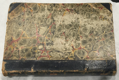
Book, Selection of Geological Publications, 09/1866
... Brough Smyth, 1866 6. Physical Geography & Geology of Victoria..., 1866 6. Physical Geography & Geology of Victoria - R.C. Selwyn ...This book was owned and used by Professor Ferdinand M. Krause of the Ballarat School of Mines.Ferdinand Krause was a renowned teacher at the Ballarat School of Mines. He also produced many important Geological Maps. This book has seven reports that Krause had bound together for his own use. Half black leather bound book with hand marbled paper cover. Marbling on cover is grey, maroon and darker grey with gold bands on black leather spine. The book contains 7 papers on various subjects associated with ores. The book includes: 1. Auriferous, Leads, & Silver Ores at Upper Hungary - G.H.F. Ulrich, 1868 2. Nuggetty Reef, Maldon, Victoria - G.H.F. Ulrich, 1866 3. Internal Communication - Lieut. Amsinck, 1856 4. Roads for Victoria - William Macredie, 1856 5. Mining & Mineral Statistics of Victoria - Robert Brough Smyth, 1866 6. Physical Geography & Geology of Victoria - R.C. Selwyn, 1866 7. Mineralogy of Victoria - G.H.F. Ulrich, 1866 Leather component is black with gold bands on spine with "Silver Ores etc" written on spine. 'G" on square cream paper at top of spine; "2" on square cream paper on middle of spine; and "3" on square cream paper on bottom of spine. Inside front cover on red paper rectangle near spine "bound by W. PAUL 17 Lydiard St BALLARAT" "Ferdinand M Krause C E" handwritten in black ink on title page of first paper (right hand side)treatment, auriferous, lead, silver ores, nuggetty reef, maldon, victoria, internal communication, roads for victoria, mining, mineral statistics, geography, geology, mineralogy, ulrich, amsinck, selwyn, ferdinand krause, macredie -
 Orbost & District Historical Society
book, Effingham, Wilson, A Geographical Dictionary of the Australian Colonies, 1848
... colonies : their physical and political geography : together... colonies : their physical and political geography : together ...A geographical dictionary or gazetteer of the Australian colonies : their physical and political geography : together with a brief notice of all the capitals, principal towns, and villages. William Wells travelled to Australia as a sponsored immigrant in 1838. Her became a freelance surveyor with an office in Bligh Street, Sydney. He wrote this book in order to better inform the British public on the colonies of Australia. The information contained in the book is both topographical and statistical and was a very useful refernece book at the time.This book is a rare detailed contemporary record of the Australian colonies in the mid 19th century.A hard back 453 pp book with a dark brown patterned cover which has a white label with the title, "Dictionary of Geography" over a map of Australia. It is illustrated with numerous maps and drawings.history-australia wells-william-henry geographical-dictionary-of-the-australian-colonies -
 Phillip Island and District Historical Society Inc.
Book, W. & A.K. Johnston, world-wide atlas of modern geography, political and physical, containing one hundred and twenty-eight plates and complete index with an introduction by J. Scott Keltie, 1906
... world-wide atlas of modern geography, political and... geography, political and physical, containing one hundred and twenty ... -
 Greensborough Historical Society
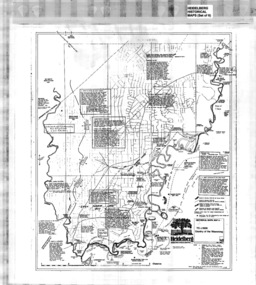
Map, Heidelberg: Historic River Landscape Assessment, Historical Maps. Map A To 1838. Country of the Wawarang, 1985c
Geographical area of around 35 sq. kilometres marked with physical features such as major roads, rivers, vegetation and properties, with contemporary notes on landowners, descriptions and comments on the land and its development. Bounded by Shire of Diamond Valley to the North, Darebin Creek to the West and Plenty River to the East.Black an white sketch map on white paperheidelberg, heidelberg - maps -
 Greensborough Historical Society
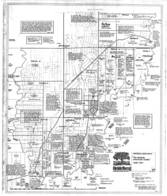
Map, Heidelberg: Historic River Landscape Assessment. Historical Maps. Map B 1838-1851, "The Distinctly aristocratic locality", 1985c
Geographical area of around 35 sq. kilometres marked with physical features such as major roads, rivers, vegetation and properties, with contemporary notes on landowners, descriptions and comments on the land and its development. Bounded by Shire of Diamond Valley to the North, Darebin Creek to the West and Plenty River to the EastBlack and white sketch map on white paperheidelberg, heidelberg - maps -
 Greensborough Historical Society
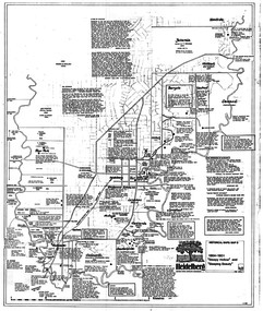
Map, Heidelberg. Historic River Landscape Assessment. Historical maps: Map C 1851-1863. "The Garden of the colony", 1985c
Geographical area of around 35 sq. kilometres marked with physical features such as major roads, vegetation and properties, with locations and notes of the increasing number of farms, gardens orchards and vineyards which had become established in addition to pastoral runs. Bounded by Shire of Diamond Valley to the North, Darebin Creek to the West and Plenty River to the East.Black and white sketch map on white paperheidelberg, heidelberg - maps -
 Greensborough Historical Society
Map, Heidelberg: Historic River Landscape Assessment. Historical maps. Map D 1864 -1901 "Sleepy Hollow" and "Sleeping beauty", 1985c
Geographical area of c. 35 sq. kilometres marked with physical features such as major roads, rivers, vegetation and properties, with locations and notes on the increasing number of farms, orchards and vineyards that had been developed in addition to pastoral runs. Bounded by Shire of Diamond Valley to the North, Darebin Creek to the West, and Plenty River to the East.Black and white sketch on white paper. Second copy 600 x 430 cm printed in black on semi-opaque paperheidelberg, heidelberg - maps -
 Greensborough Historical Society
Map, Heidelberg: Historic River Landscape Assessment. Historical maps. Map E 1901-1934 "A Time of projects and improvements", 1985c
Geographical area of around 35 sq. kilometres marked with physical features such as major roads, railways (new extension to Eltham), rivers and properties, also housing sub-divisions and community facilities such as hospitals, parks and sporting reserves and indications of new small scale industries such as dairying. Bounded by Shire of Diamond Valley to the North, Darebin Creek to the West and Plenty River to the East. Black and white sketch map on white paperheidelberg, heidelberg - maps -
 Flagstaff Hill Maritime Museum and Village
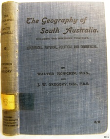
Book, The Geography of South Australia
Warrnambool's Mechanics' Institute (or Institution as it was sometimes called) was one of the earliest in Victoria. On 17th October 1853 a meeting was held where it was resolved to request the Lieutenant Governor of the Colony to grant land for the erection of a Mechanics' Institutes building. A committee was formed at the meeting and Richard Osburne chaired the first meeting of this committee. The land on the North West corner of Banyan and Merri Streets was granted but there were no funds to erect the building. The Formal Rights of the Warrnambool Mechanics' Institute's encompassed its aims and these were officially adopted in1859; "This Institution has for its object the diffusion of literary, scientific, and other useful knowledge amongst its members, excluding all controversial subjects, religious or political. These objects are sought to be obtained by means of a circulating library, a reading room, the establishment of classes, debates, and the occasional delivery of lectures on natural and experimental philosophy, mechanics, astronomy, chemistry, natural history, literature, and the useful and ornamental arts, particularly those which have a more immediate reference to the colony." The Warrnambool Mechanics' Institute opened its first reading room in November1884 in the National School building at the corner of Banyan and Timor Streets. The Institute was funded by member subscription, payable on a quarterly, half yearly or yearly basis. Samuel Hannaford, the Manager of the Warrnambool Bank of Australasia, was the first Honorary Secretary of the Mechanics' Institutes, and an early President and Vice-President. He also gave several of the early lectures in the Reading Room. Another early Secretary, Librarian and lecturer was Marmaduke Fisher, the teacher at the National School. Lecture topics included The Poets and Poetry of Ireland', 'The Birth and Development of the Earth', 'The Vertebrae - with Remarks on the pleasures resulting from the study of Natural History' and 'Architecture'. In 1856 the Reading Room was moved to James Hider's shop in Timor Street, and by 1864 it was located in the bookshop of Davies and Read. In the 1860's the Mechanics' Institute struggled as membership waned but in 1866, after a series of fund raising efforts, the committee was able to purchase land in Liebig Street, on a site then called Market Square, between the weighbridge and the fire station. A Mechanics' Institute building was opened at this site in August 1871. The following year four more rooms were added to the main Reading Room and in 1873 the Artisan School of Design was incorporated into the Institute. The same year Joseph Archibald established a Museum; however it deteriorated when he was transferred to Bendigo in 1877. In 1880, with Archibald's return to Warrnambool, the Museum was re-established, and in 1885 a new building was built at the back of the Institute to accommodate the re-created School of Design, the Art Gallery and the Museum. In 1887 the Museum section was moved to the former court house in Timor Street (for some time the walls of the building formed part of the TAFE cafeteria but all is now demolished)). In 1911 the Museum was transferred back to the original building and the management of the Mechanics' Institute was handed over to the Warrnambool City Council. The Museum and Art Gallery became one and housed many fine works of art, and the Library continued to grow. The building was well patronised, with records showing that at the beginning of the 20th century there were between 500 and 800 visitors. During World War One the monthly figures were in the thousands, with 3,400 people visiting in January 1915. The Museum was a much loved Institution in Warrnambool until the contents of the Museum and Art Gallery were removed to make room for the Warrnambool City Council Engineers' Department. The contents were stored but many of the items were scattered or lost. When the original building was demolished the site became occupied by the Civic Centre, which included the new City Library. (The library was temporarily located in the old Palais building in Koroit Street.) In the process of reorganisation the Collection was distributed amongst the community groups: -The new City Library took some of the historic books and some important documents, historic photographs and newspapers. -The Art Gallery kept the 19th Century art collection and some of the artefacts from the museum. -The Historic Society has some items -The State Museum has some items -Some items were destroyed -Flagstaff Hill Maritime Village has old newspapers, Government Gazettes, most of the Mechanics' Institute Library, ledgers and documents connected to the Mechanics' Institute Library, some framed and unframed art works and some photographs. The Warrnambool Mechanics' Institute Library book collection is deemed to be of great importance because it is one of the few collections in an almost intact state, and many of the books are now very rare and of great value. The Geography of South Australia including The Northern Territory Historical, Physical, Political and Commercial Author: Walter Howchin Publisher: Whitcombe and Tombs Ltd Date: 1911Label on spine cover with typed text RA 911.942 HOW Pastedown front endpaper has sticker from Warrnambool Mechanics Institute and Free Librarywarrnambool, shipwrecked-coast, flagstaff-hill, flagstaff-hill-maritime-museum, maritime-museum, shipwreck-coast, flagstaff-hill-maritime-village, shipwrecked-artefact, great ocean road, book, warrnambool library, warrnambool mechanics’ institute, mechanics’ institute library, victorian library board, warrnambool books and records, warrnambool children’s library, warrnambool public library -
 Flagstaff Hill Maritime Museum and Village
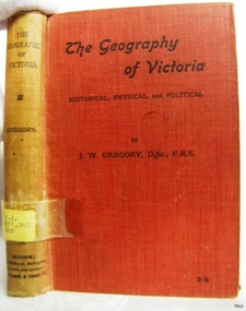
Book, The Geography of Victoria
... The Geography of Victoria Historical, Physical... The Geography of Victoria Historical, Physical and Political Author: J W ...Warrnambool's Mechanics' Institute (or Institution as it was sometimes called) was one of the earliest in Victoria. On 17th October 1853 a meeting was held where it was resolved to request the Lieutenant Governor of the Colony to grant land for the erection of a Mechanics' Institutes building. A committee was formed at the meeting and Richard Osburne chaired the first meeting of this committee. The land on the North West corner of Banyan and Merri Streets was granted but there were no funds to erect the building. The Formal Rights of the Warrnambool Mechanics' Institute's encompassed its aims and these were officially adopted in1859; "This Institution has for its object the diffusion of literary, scientific, and other useful knowledge amongst its members, excluding all controversial subjects, religious or political. These objects are sought to be obtained by means of a circulating library, a reading room, the establishment of classes, debates, and the occasional delivery of lectures on natural and experimental philosophy, mechanics, astronomy, chemistry, natural history, literature, and the useful and ornamental arts, particularly those which have a more immediate reference to the colony." The Warrnambool Mechanics' Institute opened its first reading room in November1884 in the National School building at the corner of Banyan and Timor Streets. The Institute was funded by member subscription, payable on a quarterly, half yearly or yearly basis. Samuel Hannaford, the Manager of the Warrnambool Bank of Australasia, was the first Honorary Secretary of the Mechanics' Institutes, and an early President and Vice-President. He also gave several of the early lectures in the Reading Room. Another early Secretary, Librarian and lecturer was Marmaduke Fisher, the teacher at the National School. Lecture topics included The Poets and Poetry of Ireland', 'The Birth and Development of the Earth', 'The Vertebrae - with Remarks on the pleasures resulting from the study of Natural History' and 'Architecture'. In 1856 the Reading Room was moved to James Hider's shop in Timor Street, and by 1864 it was located in the bookshop of Davies and Read. In the 1860's the Mechanics' Institute struggled as membership waned but in 1866, after a series of fund raising efforts, the committee was able to purchase land in Liebig Street, on a site then called Market Square, between the weighbridge and the fire station. A Mechanics' Institute building was opened at this site in August 1871. The following year four more rooms were added to the main Reading Room and in 1873 the Artisan School of Design was incorporated into the Institute. The same year Joseph Archibald established a Museum; however it deteriorated when he was transferred to Bendigo in 1877. In 1880, with Archibald's return to Warrnambool, the Museum was re-established, and in 1885 a new building was built at the back of the Institute to accommodate the re-created School of Design, the Art Gallery and the Museum. In 1887 the Museum section was moved to the former court house in Timor Street (for some time the walls of the building formed part of the TAFE cafeteria but all is now demolished)). In 1911 the Museum was transferred back to the original building and the management of the Mechanics' Institute was handed over to the Warrnambool City Council. The Museum and Art Gallery became one and housed many fine works of art, and the Library continued to grow. The building was well patronised, with records showing that at the beginning of the 20th century there were between 500 and 800 visitors. During World War One the monthly figures were in the thousands, with 3,400 people visiting in January 1915. The Museum was a much loved Institution in Warrnambool until the contents of the Museum and Art Gallery were removed to make room for the Warrnambool City Council Engineers' Department. The contents were stored but many of the items were scattered or lost. When the original building was demolished the site became occupied by the Civic Centre, which included the new City Library. (The library was temporarily located in the old Palais building in Koroit Street.) In the process of reorganisation the Collection was distributed amongst the community groups: -The new City Library took some of the historic books and some important documents, historic photographs and newspapers. -The Art Gallery kept the 19th Century art collection and some of the artefacts from the museum. -The Historic Society has some items -The State Museum has some items -Some items were destroyed -Flagstaff Hill Maritime Village has old newspapers, Government Gazettes, most of the Mechanics' Institute Library, ledgers and documents connected to the Mechanics' Institute Library, some framed and unframed art works and some photographs. The Warrnambool Mechanics' Institute Library book collection is deemed to be of great importance because it is one of the few collections in an almost intact state, and many of the books are now very rare and of great value. The Geography of Victoria Historical, Physical and Political Author: J W Gregory Publisher: Whitcombe and Tombs Ltd Date: 1904Label on spine cover with typed text RA 911.945 GRE Pastedown front endpaper has sticker from Warrnambool Mechanics Institute and Free Librarywarrnambool, shipwrecked-coast, flagstaff-hill, flagstaff-hill-maritime-museum, maritime-museum, shipwreck-coast, flagstaff-hill-maritime-village, shipwrecked-artefact, great ocean road, book, warrnambool library, warrnambool mechanics’ institute, mechanics’ institute library, victorian library board, warrnambool books and records, warrnambool children’s library, warrnambool public library, the geography of victoria, j w gregory -
 Bendigo Military Museum
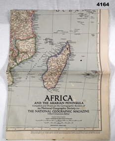
Map - MAP, COLOURED, The National geographic Magazine, Africa & the Arabian Peninsula, March 1950
Part of the collection of Frederick Gardner Davey DFC No 410533 RAAF. Refer Cat No 3536P for his service details.Coloured political map featuring borders,towns,and Allies, small physical inset in bottom LH corner.maps, africa, arabian -
 Kiewa Valley Historical Society
Atlas Australian Commonwealth, Philips' Australian Commonwealth Atlas, 1944
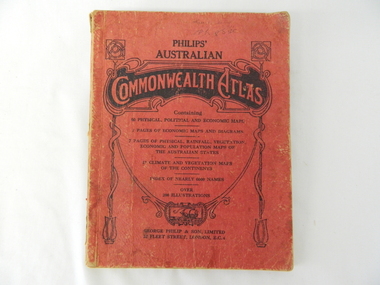
This atlas, printed in 1944, details not only the geographic and political boundaries of the world as it was at that time but also the snap shot of life of the time. This snap shot in time covers the major Australian cities, the major farming, grazing, industrial and sporting/recreational activities. Also there are snap shots of similar activities from other global areas. The period also covered World War II, detailed by a photo of "shell making", munitions, required by Australian soldiers. The great political and territorial changes made as a result of World War II can be clearly identified for example , Israel (the Jewish homeland). The various prewar colonies of major European nations.This atlas was used by children of a Kiewa Valley family and shows the value and the general educational exposure that these children had at this time. The rural setting and within the backdrop of a world war did not severely alter the life style of children in this region. The "news reels" shown in cinemas of cities and larger towns were the only visual realisations of major events of global significance available to these children. The information provided by this atlas allowed students to glimpse at what the "outside world" was. The majority of these students would possibly never see these regions for themselves. The great communication facilities of the late 1900s and beyond, was still only science fiction.This atlas has a thick (350 g/m) red cardboard cover with bold black lettering and shading. The cover is set out within a shield like frame. The shield is held up by two square markings, each with a four part circular pattern and a cord entwining two pendulum structures ending with a bowl figure at the bottom. There is a semi circular form enclosing a printed book contents list. The inside cover has the atlas title and contents and the publisher details. The atlas contain 56 pages of world and Australian maps, vegetation and rainfall maps. Within this atlas there are 27 double sided pages of black and white photographs depicting life styles, buildings, landscapes and prominent and significant to Australia males from 1652 to 1944. The pages are of approximately 200 g/m and have the yellow aged appearance.On front cover "Philips' Australian COMMONWEALTH ATLAS" and underneath "Containing" underneath "60 PHYSICAL, POLITICAL AND ECONOMIC MAPS". Publisher George Philip & Son, Limited 32 Fleet Street, London E.C. 4. Inside cover are: written, in freehand and in ink the following names and dates; "J.Muller Form V 1945", "L L Muller Form IV 1946", "N.J. Muller Form I + II + III 1948 +49 + 50" and "D Muller Form I 1949". also handwritten and in pencil is "Peter Leslie". On the last page is a small freehand sketch of Australia in biro.1940s school curriculum, rural education, 1940s atlas, australian atlas -
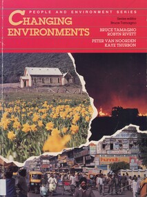 Surrey Hills Historical Society Collection
Book, Changing environments, 1990
There is a chapter dedicated to the physical and built environment of Surrey Hills and surrounding area. It includes maps drawn from the work of Alan Holt. The late Robyn Rivett (Rhodes) taught geography before becoming a curriculum adviser within the Education Department. She lived in Surrey Hills.Surrey Hills Neighbourhood Centre - historyhuman ecology, anthropo - geography, (mr) bruce tamango, people and environment series, streetscapes, (mrs) robyn rivett, (mrs) robyn rhodes, (mr) alan holt, surrey hills -
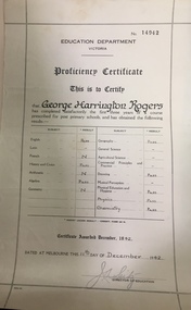 Kew Historical Society Inc
Certificate, Education Department (Victoria), Proficiency Certificate: George Harrington Rogers, 11/12/1942
... results. Pass - English, History and Civics, Algebra, Geography... results. Pass - English, History and Civics, Algebra, Geography ...This document was donated to the Kew Historical Society by John Rogers in 2015. Primary source for understanding the requirements of educational standards in Victoria in the 1940sEducation Department Victoria. Proficiency Certificate No.14942 This is to Certify that George Harrington Rogers has completed satisfactorily the first three years of a course prescribed for post primary school, and had obtained the following results. Pass - English, History and Civics, Algebra, Geography, Drawing, Physical Education and Hygiene, Physics, Chemistry. Certificate awarded 1942. Dated at Melbourne this 11th Day of December 1942. Signed Director of Education.certificates - education department victoria, proficiency certificates, george harrington rogers -
 Kew Historical Society Inc
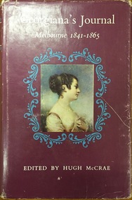
Book, Georgiana’s Journal: Melbourne 1841-1865, 1966
This diary tells the Australian story as it has never been told before and can never be told again. The journal consists mainly of entries in her diary made by Georgiana day by day as events took place. p.91; Brief mention of natives, fear of comet; p.100; Custom of exchanging names; plate facing p. 201 : portraits of Aboriginal people from Arthur's seat; p.204; Account of formation of Port Phillip Bay; p.213; Burial described; p.243; Words of songs of Goulburn blacks tribe; p.245; Description of a corroboree of men, and one of children; Place of women; p.247-253 is An Essay hostorical, geographical, anthropological and zoological taken from Georges Cahier dEcriture 1846; P.250; Description of the natives of New Holland - physical appearance, way of life, dances, shelters, food, weapons, method of stretching opossum skins; Vic. (S) - 6/9, 5/7, 5/5, 5/6, 4/7, 8/1.[Sydney] Angus and Robertson [1966] xxi, 262 p. illus., maps, ports. (part col.) 24 cm. non-fictionThis diary tells the Australian story as it has never been told before and can never be told again. The journal consists mainly of entries in her diary made by Georgiana day by day as events took place. p.91; Brief mention of natives, fear of comet; p.100; Custom of exchanging names; plate facing p. 201 : portraits of Aboriginal people from Arthur's seat; p.204; Account of formation of Port Phillip Bay; p.213; Burial described; p.243; Words of songs of Goulburn blacks tribe; p.245; Description of a corroboree of men, and one of children; Place of women; p.247-253 is An Essay hostorical, geographical, anthropological and zoological taken from Georges Cahier dEcriture 1846; P.250; Description of the natives of New Holland - physical appearance, way of life, dances, shelters, food, weapons, method of stretching opossum skins; Vic. (S) - 6/9, 5/7, 5/5, 5/6, 4/7, 8/1.mcrae, georgiana, georgiana mccrae, woman on victorian goldfields -
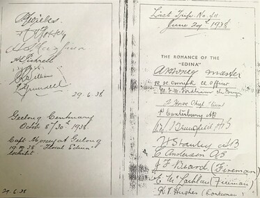 Queenscliffe Maritime Museum
Document - copy of extract
Title: The romance of the "Edina" : the world's oldest screw-steamship : with chapters on the auxiliary steamship :Great Britain", and the Port Phillip Bay steamers past and present / by C. Dickson Gregory Author: Gregory, C. Dickson (Charles Dickson) Publication Information: Melbourne : Robertson & Mullens, 1935 Physical Description: xii, 84 p., [24] p. of plates : ill. ; 23 cm Series Link: Queenscliffe Maritime Museum General Note: Item no. Corporate Subject: Edina (Ship) Great Britain (Ship) Subject Term: Shipping -- Victoria Geographic Term: Port Phillip Bay Region (Vic.) -- History Format: Books Holds: 0 Copies: 2This iron hull single screw steamer had a long and distinguished carrier operating between 1853 and 1938. She served in the Crimean war carrying stores and horses to the Black Sea and later trading in the Mediterranean, and carrying cotton for the Confederate States in the American Civil War. Edina arrived in Melbourne under sail in March 1863 and was purchased by Stephen Henty for use from ports in western Victoria and later carried gold prospectors across the Tasman to New Zealand. After a refit in 1870 she was used in the coastal trade along the Queensland coast for Howard Smith until returning to Victoria and the Melbourne-Geelong trade as a cargo-passenger vessel. The Edina had two narrow escapes from destruction in 1898 and 1899 when she collided with other steamers, both being sunk. A further refit in 1917 altered her appearance with a new mast, funnel, bridge and promenade deck. By 1924 Edina had made over 12,000 Melbourne-Geelong passages and carried over one million people on the service. A further collision in July 1931 which sank the tug Hovell forced Edina onto a mudbank on Port Phillip Bay. She was taken out of service in 1938 but was later renamed Dinah and used as a lighter until 1958 when she was broken up and her remains used as land-fill.Extract from the book 'The Romance of the Edina' showing signatures of her last voyage crew in 1938.'The Romance of the Edina'ss edina, port phillip, steam ships -
 Eltham District Historical Society Inc
Folder, The Physical characteristics and historical development of the Shire of Eltham by Russell Yeoman, 1980
12 page essay describing the physical characteristics, major landform features and historical development of the Shire of Eltham. Includes photocopy of part of unsourced newspaper article describing early land holders and roads in the area.14 pagesHG Booklet 38harry gilham collection, russell yeoman, geography, history -
 Eltham District Historical Society Inc
Folder, The Victorian Gazetteer of 1865. Entries for Eltham and Kangaroo Ground, 1999
The Gazetteer is a geographical dictionary or directory for place names in Victoria. Entries for Eltham and Kangaroo Ground have been photocopied. These entries provide physical descriptions, some description of local industry and amenities and more at the time of publication in 1865.3 pages. Copies HG Booklet 118harry gilham collection, gazetteer, eltham, kangaroo ground, 1865 -
 The Mrs Aeneas Gunn Memorial Library
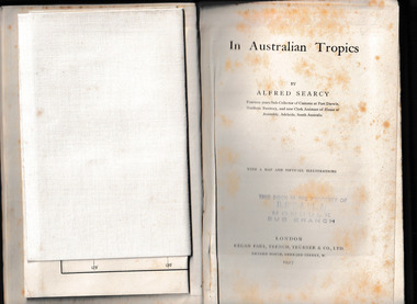
Book, Kegan Paul Trench Trubner and Co, In Australian tropics, 1907
Early history of N.T. and explorations; Detailed account of intercepting Macassan proas around coast of Arnhem Land whilst author was Sub-Collector of Customs for 14 years; Names of proas and masters, Malay camps & smoke houses along coast & nearby islands; Natives employed by Malays in trepang fishing and collecting tortoiseshell, relationships between Malays and Aborigines; influences (physical & cultural); Habit of exchanging children between tribes (Roper R. & Normanton) for the purpose of learning each others language & customs; Description of native camps at Fort Dundas (1895) shelters, finding of bark water bags, types of canoes used; Platform burial at Daly R.; Sacred burial site on Maria Island; Geographical features, vegetation, climate etc., general ecology, depredations & murders by natives; Cannibalism practiced by Fitzmaurice River tribes.Ill, maps, p.373.non-fictionEarly history of N.T. and explorations; Detailed account of intercepting Macassan proas around coast of Arnhem Land whilst author was Sub-Collector of Customs for 14 years; Names of proas and masters, Malay camps & smoke houses along coast & nearby islands; Natives employed by Malays in trepang fishing and collecting tortoiseshell, relationships between Malays and Aborigines; influences (physical & cultural); Habit of exchanging children between tribes (Roper R. & Normanton) for the purpose of learning each others language & customs; Description of native camps at Fort Dundas (1895) shelters, finding of bark water bags, types of canoes used; Platform burial at Daly R.; Sacred burial site on Maria Island; Geographical features, vegetation, climate etc., general ecology, depredations & murders by natives; Cannibalism practiced by Fitzmaurice River tribes. northern australia - description and travel, ethnography -
 Ballarat Heritage Services
Digital photograph, Dorothy Wickham, Tower of London, 2016
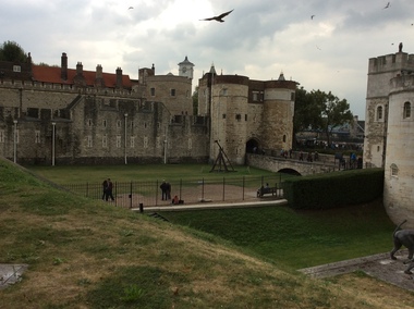
The Tower of London, officially Her Majesty's Royal Palace and Fortress of the Tower of London, is a historic castle located on the north bank of the River Thames in central London. It lies within the London Borough of Tower Hamlets, separated from the eastern edge of the square mile of the City of London by the open space known as Tower Hill. It was founded towards the end of 1066 as part of the Norman Conquest of England. The White Tower, which gives the entire castle its name, was built by William the Conqueror in 1078, and was a resented symbol of oppression, inflicted upon London by the new ruling elite. The castle was used as a prison from 1100 (Ranulf Flambard) until 1952 (Kray twins),[3] although that was not its primary purpose. A grand palace early in its history, it served as a royal residence. As a whole, the Tower is a complex of several buildings set within two concentric rings of defensive walls and a moat. There were several phases of expansion, mainly under Kings Richard the Lionheart, Henry III, and Edward I in the 12th and 13th centuries. The general layout established by the late 13th century remains despite later activity on the site. The Tower of London has played a prominent role in English history. It was besieged several times, and controlling it has been important to controlling the country. The Tower has served variously as an armoury, a treasury, a menagerie, the home of the Royal Mint, a public record office, and the home of the Crown Jewels of England. From the early 14th century until the reign of Charles II, a procession would be led from the Tower to Westminster Abbey on the coronation of a monarch. In the absence of the monarch, the Constable of the Tower is in charge of the castle. This was a powerful and trusted position in the medieval period. In the late 15th century the castle was the prison of the Princes in the Tower. Under the Tudors, the Tower became used less as a royal residence, and despite attempts to refortify and repair the castle its defences lagged behind developments to deal with artillery. The peak period of the castle's use as a prison was the 16th and 17th centuries, when many figures who had fallen into disgrace, such as Elizabeth I before she became queen, Sir Walter Raleigh, and Elizabeth Throckmorton were held within its walls. This use has led to the phrase "sent to the Tower". Despite its enduring reputation as a place of torture and death, popularised by 16th-century religious propagandists and 19th-century writers, only seven people were executed within the Tower before the World Wars of the 20th century. Executions were more commonly held on the notorious Tower Hill to the north of the castle, with 112 occurring there over a 400-year period. In the latter half of the 19th century, institutions such as the Royal Mint moved out of the castle to other locations, leaving many buildings empty. Anthony Salvin and John Taylor took the opportunity to restore the Tower to what was felt to be its medieval appearance, clearing out many of the vacant post-medieval structures. In the First and Second World Wars, the Tower was again used as a prison, and witnessed the executions of 12 men for espionage. After the Second World War, damage caused during the Blitz was repaired, and the castle reopened to the public. Today the Tower of London is one of the country's most popular tourist attractions. Under the ceremonial charge of the Constable of the Tower, it is cared for by the charity Historic Royal Palaces and is protected as a World Heritage Site.(Wikipedia) A World Heritage Site is a landmark which has been officially recognized by the United Nations, specifically by UNESCO. Sites are selected on the basis of having cultural, historical, scientific or some other form of significance, and they are legally protected by international treaties. UNESCO regards these sites as being important to the collective interests of humanity. More specifically, a World Heritage Site is an already classified landmark on the earth, which by way of being unique in some respect as a geographically and historically identifiable piece is of special cultural or physical significance (such as either due to hosting an ancient ruins or some historical structure, building, city, complex, desert, forest, island, lake, monument, or mountain) and symbolizes a remarkable footprint of extreme human endeavour often coupled with some act of indisputable accomplishment of humanity which then serves as a surviving evidence of its intellectual existence on the planet. And with an ignoble intent of its practical conservation for posterity, but which otherwise could be subject to inherent risk of endangerment from human or animal trespassing, owing to unmonitored/uncontrolled/unrestricted nature of access or threat by natural or accelerated extinction owing to local administrative negligence, hence it would have been listed and demarcated by the United Nations Educational, Scientific and Cultural Organization (UNESCO) to have been identified or recognised and officially christened and internationally elevated through multilateral declaration by UNESCO as a universally protected zone. [1] The list is maintained by the international World Heritage Programme administered by the UNESCO World Heritage Committee, composed of 21 UNESCO member states which are elected by the General Assembly. (Wikipedia)The Tower of London is a UNESCO world heritage site.tower of london -
Federation University Historical Collection
Document - Document - Syllabus, Education Department, Victoria, Syllabus No. J1 (Girls), Junior Technical Schools
This syllabus for Girls provides the suggested time-allotment for subjects in Year 1, Year 2 and Year 3. The total hours for each year is 40 hours. Years 1 & 2 have classes in English - 5 hours; Social Studies which covers History and Civics and Geography - 4 hours; Art which covers Model Drawing, Plant Forms, Lettering and Geometrical Drawing - 6 hours; Needlecrafts which covers Plain and Decorative Needlework, Dressmaking, Millinery - 6 hours; Homecrafts which covers Cookery, Laundry, Housewifery - 4 hours; Horticulture or Special approved subjects - 2 hours; Sports, Physical Drill and Singing - 4 hours. Year 3 have English - 5 hours; Civics - 2 hours; Arithmetic and Elementary Bookkeeping - 4 hours; Science - 4 hours; Special approved subjects - 1 hour; Sports, Physical Drill and Singing - 4 hours giving a total of 20 hours. The remaining 20 hours will be for one of the following groups - (a) Dressmaking, (b) Millinery, (c) Art and Craft, (d) Cookery, (e) Homecrafts.21cm x 27.2cm sheet folded to 21cm x 13.7 education department, victoria, syllabus, girls, junior technical schools, time-allotment, hours per subject, english, social studies, history and civics, geography, hygiene and elementary physiology, arithmetic, science, art, model drawing, plant form, lettering, geometrical drawing, needlecrafts, plain and decorative needlework, dressmaking, millinery, homecrafts, cookery, laundry, housewifery, horticulture, sports, physical drill, singing, art and applied design, drafting, history and appreciation of art -
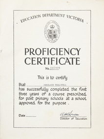 Merbein District Historical Society
Certificate - Proficiency Certificate
Proficiency certificate A4 certificate No 107909Front education department Victoria logo in oval with coat of arms and crown Proficiency certificate NO 107909 This is to certify that Penelope Treadwell has successfully completed the first three years of a course prescribed for post primary schools at a school approved for the purpose director of education Back the candidate has completed a course of study in the following subjects with results as indicated English pass, algebra pass, geometry pass, geography pass, general science pass agricultural science, French credit pass , German, Latin, history pass, social studies , musical appreciation, art credit pass, shorthand, home management including cookery, needle work credit pass, crafts, woodwork, metalwork, blacksmithing, mechanical drawing, physical education pass. education, penelope treadwell, proficiency certificate